Forward an email to: data@fla-etat.org
The email should include:
The EST provides a Map Viewer for viewing ETDM projects.
The ETDM project map services are also available for people to use in their own Geographic Information System (GIS) software.
The ETDM project features are available in three feature map services provided by REST endpoints:
Currently in ETAT Review Projects currently seeking comments in an active review. https://aquarius.at.geoplan.ufl.edu/arcgis/rest/services/oem_services/ETAT_REVIEW_PROD/FeatureServer
Previously Reviewed Projects that have completed an ETAT review. https://aquarius.at.geoplan.ufl.edu/arcgis/rest/services/oem_services/PREVIOUSLY_REVIEWED_PROD/FeatureServer
Eliminated Project alternatives that have been eliminated from further consideration. https://aquarius.at.geoplan.ufl.edu/arcgis/rest/services/oem_services/ELIMINATED_PROD/FeatureServer
The following instructions describe how to add this data when using ArcGIS Pro:
The ETDM Agreements between FHWA, FDOT, and the other participating agencies serve as a catalyst for agency participation in the ETDM Process. Currently, there are three separate agreements employed within the ETDM Program: the Master Agreement, Agency Operating Agreement, and Funding Agreement. All three agreements contribute to the successful maintenance and operation of the ETDM Process, with the leading agreement being the Funding Agreement. Each participating agency negotiates the terms and conditions of its agreements based on the agency's regulatory and statutory requirements and funding resource needs.
Links to the Memorandum of Understanding and Agency Operating Agreements are listed below.
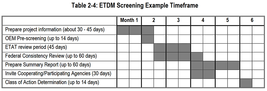
At the beginning of both the Planning Screen and Programming Screen, the ETDM coordinators notify the ETAT members (including CLCs) to begin reviewing project effects through the Environmental Screening Tool (EST). This notification begins the 45-day ETAT review period. The Community Liaison Coordinators engage with community leaders. The public may sign up for notifications on the ETDM Public Access Site. At this time, the public may review project data, results of GIS analyses, and corresponding resource mapping, using the EST or through the MPO or district office. During the 45-day review period, the ETAT members enter their comments into the EST. Others provide input to MPOs, FDOT, and the resource agencies through normal public involvement channels (e.g. workshops, correspondence, telephone communication, etc.).
The ETDM coordinators are required to summarize and respond to the ETAT comments within 60-days of the end of a review period. These summary reports are made available to the public as soon as the ETDM coordinator posts the finalized summary report. Following the screening events, the project information, GIS results, mapping, ETAT reviews, and summary reports will continue to be available to the public through the web site. At the beginning of subsequent ETDM phases, any updates to project information are posted to the public access site. A history record of the project is maintained and made available as well. Throughout Project Development, project managers upload technical studies and environmental documents into the EST. They can also provide links to any project-specific web sites. Links to these documents and web sites are available through the project description report.